
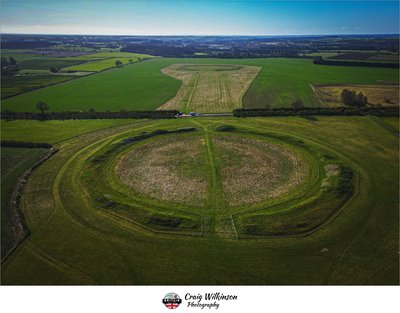
Thornborough Henge
Legacy location #236.
Photos at this Location
None
Sun & Moon Positions
Sun and moon directions from your standing position
—
—
Milky Way
Kp 3.038.6 nT
Sun and moon lines start from the blue person (your standing point). Orange camera = photo location. Unlock the padlock, then drag the person or camera—or tap the map—to adjust positions (not saved).
Photography Planning
What3Words
Add an API key in Admin → API Keys to enable.
EXIF Data
0 photos with camera metadata
Location Details
- Address: Unnamed Road, Ripon, UK
- Latitude / Longitude: 54.209019, -1.562848
- Grid Ref: SE2861079341
-
Added by:
 Craig
Craig
Drone restrictions
- Log in to see flight restriction zones for this location.
Tidal location
Loading tide times…
View Statistics
- Total views101
- Today5
- This week11
- This month42
Nearby Locations
- West Tanfield, Under Bridge 1.1 mi
- Hackfall Car Park 3.6 mi
- Himalayan Garden & Sculpture Park 4.7 mi
- Fountains Abbey 6.9 mi
- Druids Temple 6.9 mi
Location Comment / Info (0)
Log in as a member to post a comment.
No comments or info yet.