
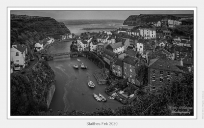
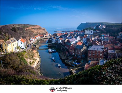
Staithes
Staithes is a picturesque fishing village located on the North Yorkshire coast, known for its charming cobbled streets and colourful cottages that cling to the cliffs overlooking the North Sea. The village's historical maritime heritage is evident in its bustling harbour and the dramatic coastal scenery that surrounds it.
Photographers will find a wealth of subjects to capture, from the vibrant fishing boats in the harbour to the rugged cliffs and crashing waves. The best light for photography is often during the golden hours of sunrise and sunset, which enhance the colours of the buildings and the sea. Throughout the year, Staithes offers a variety of moods, with dramatic skies and changing tides providing endless opportunities for dynamic compositions.
Photography notes:
- Arrive early to capture the soft morning light and avoid crowds.
- Explore different vantage points along the cliffs for unique perspectives of the village.
- Consider using a polarising filter to enhance the colours of the sea and sky.
Photos at this Location
Most visitors arrive in Staithes via the A174 road, which leads directly into the village. The scenic drive offers glimpses of the coastline, making it a delightful approach for photographers anticipating stunning views.
Parking:
- The main car park is located at the eastern edge of Staithes on Cowbar Lane (Postcode: TS13 5AD). This car park is approximately a 10-minute walk (0.5 miles) to the harbour area, where many iconic shots of the village can be captured. The walk is downhill initially, but be prepared for a moderate incline on the return.
- An alternative parking option is the lay-by on the A174, which allows for quick access to the cliffs above the village. However, parking here is limited and may require a longer walk of about 15-20 minutes down into Staithes, depending on your starting point.
Access:
- The paths leading down to the harbour are well-trodden but can be uneven and steep in places. Cobblestones and some steps may be encountered, so sturdy footwear is advisable, especially if conditions are wet.
- Staithes is situated within a designated conservation area, and while there are no strict restrictions on photography, it is important to respect private properties and local residents.
- Photographers should consider the changing tides when planning their shots, especially if venturing closer to the water's edge. Be cautious of slippery rocks and strong waves. Arriving early in the morning can provide both the best light and a quieter atmosphere, allowing for more contemplative photography without crowds.
Sun & Moon Positions
Sun and moon directions from your standing position
—
—
Milky Way
Kp 0.710.0 nT
Sun and moon lines start from the blue person (your standing point). Orange camera = photo location. Unlock the padlock, then drag the person or camera—or tap the map—to adjust positions (not saved).
Photography Planning
What3Words
///wide.tornado.albatross
EXIF Data
1 photo with camera metadata
Photo EXIF Data
Staithes Feb 2020 - February 09, 2020
Camera: Canon EOS 5D Mark III
Date taken: 2020:02:11 23:32:15
Location Details
- Address: —
- Latitude / Longitude: 54.558811, -0.792039
- Grid Ref: NZ7821518846
- What3Words: ///wide.tornado.albatross
-
Added by:
 Craig
Craig
Drone restrictions
- Log in to see flight restriction zones for this location.
Tidal location
Loading tide times…
View Statistics
- Total views23
- Today1
- This week8
- This month23
Nearby Locations
- Saltburn Cliff Tramway 7.4 mi
- Saltburn Pier 7.4 mi
- Whitby Abbey (EH) 8.9 mi
- Black Nab 10.0 mi
- Mallyan Spout Waterfall 11.4 mi
Location Comment / Info (0)
Log in as a member to post a comment.
No comments or info yet.