
Winskill Stones
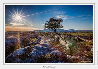
Winskill Stones is a striking limestone pavement located near the village of Langcliffe in the Yorkshire Dales. This geological formation features a unique landscape of clints and grikes, offering a dramatic backdrop against the surrounding moorland and the distant peaks of the Dales.
Photographers can capture the intricate patterns of the limestone as well as the seasonal changes in vegetation, particularly in spring and autumn when the colours are vibrant. Early morning or late afternoon light enhances the textures and shadows, making it an ideal time for landscape photography.
Photography notes:
- Arrive early to take advantage of the soft morning light for the best texture and shadow play.
- Explore different angles to find unique compositions among the limestone formations.
- Consider including the surrounding landscape to provide context and scale to your images.
Photos at this Location
Most visitors to Winskill Stones arrive via the village of Langcliffe, which serves as a convenient starting point for accessing the limestone pavement. The area is popular with walkers and photographers alike, drawn by the stunning geological features and natural beauty.
Parking:
- The nearest parking option is the small lay-by located on the B6479 road, approximately 0.5 miles from Winskill Stones. This lay-by can accommodate a few cars, but it fills up quickly during busy periods. From here, it is a 10-15 minute walk along a well-trodden path leading to the limestone formations.
- Alternatively, there is a larger car park near the village of Settle, about 1.5 miles away. This option provides more space, but the walk to Winskill Stones will take around 30 minutes through the scenic countryside.
Access:
- The path from the lay-by to Winskill Stones is generally flat and well-defined, though it can become muddy after rain, so sturdy footwear is recommended. There are no steps or stiles, making it accessible for most visitors.
- The land around Winskill Stones is designated as Open Access, allowing for free exploration, but be mindful of livestock in the area, particularly during lambing season.
- Photographers should plan to arrive early to capture the soft morning light, which enhances the textures of the limestone and the surrounding landscape. The play of shadows in the late afternoon also offers excellent opportunities. Be cautious of changing weather conditions and the potential for slippery surfaces, especially in winter.
Sun & Moon Positions
Sun and moon directions from your standing position
—
—
Milky Way
Kp 2.315.1 nT
Sun and moon lines start from the blue person (your standing point). Orange camera = photo location. Unlock the padlock, then drag the person or camera—or tap the map—to adjust positions (not saved).
Photography Planning
What3Words
Add an API key in Admin → API Keys to enable.
EXIF Data
0 photos with camera metadata
Location Details
- Address: —
- Latitude / Longitude: 54.089329, -2.254547
- Grid Ref: SD8344865966
-
Added by:
 Craig
Craig
Drone restrictions
- Log in to see flight restriction zones for this location.
Tidal location
Loading tide times…
View Statistics
- Total views21
- Today3
- This week9
- This month21
Nearby Locations
- Winskill Lone Tree 0.2 mi
- Catrigg Force 0.7 mi
- Lime Kiln 0.7 mi
- Scaleber Force Waterfall 2.1 mi
- Malham Tarn 3.7 mi
Location Comment / Info (0)
Log in as a member to post a comment.
No comments or info yet.