
Spurn Point Lighthouse
Legacy location #146.
Photos at this Location
None
Sun & Moon Positions
Sun and moon directions from your standing position
—
—
Milky Way
Kp 1.06.5 nT
Sun and moon lines start from the blue person (your standing point). Orange camera = photo location. Unlock the padlock, then drag the person or camera—or tap the map—to adjust positions (not saved).
Photography Planning
What3Words
Add an API key in Admin → API Keys to enable.
EXIF Data
1 photo with camera metadata
Photo EXIF Data
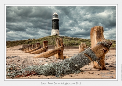
Spurn Point Groins & Lighthouse, 2011
Camera: Canon EOS 5D Mark II
Date taken: 2018:03:01 23:52:57
Location Details
- Address: Unnamed Road, Hull HU12 0UG, UK
- Latitude / Longitude: 53.578972, 0.118372
- Grid Ref: TA4034811239
- Wiki: Spurn (opens in new tab)
-
Added by:
 Craig
Craig
Drone restrictions
- Log in to see flight restriction zones for this location.
Tidal location
Loading tide times…
View Statistics
- Total views40
- Today1
- This week10
- This month40
Nearby Locations
- Humber Bridge (Barton) 24.6 mi
- Humber Bridge 25.1 mi
- Beverley Minster 28.6 mi
Location Comment / Info (0)
Log in as a member to post a comment.
No comments or info yet.